
Page content
Walking & Hiking
 Sušice Cobweb
To learn more about Sušice, follow the „Sušice Cobweb“. The eight educational trails will take you through the town and its surroundings. You will see the town from many different angles – as a Royal town rich in history and cultural landmarks but also as a modern town featuring beautiful architecture from the 20th century. You will see a Sušice which was once the cradle of match production but also a town that supported the Hussite movement. The Stations of the Cross will offer you an opportunity to rest and ponder. There is also a trail along the River Otava where you can go wild with your kids. This network of circa 20 km of walks is marked with the sign of a cobweb. Each walk has its own colour.
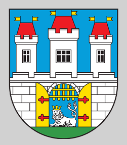
SUŠICE THE ROYAL TOWN
| Length of the route: | 2 km (slow walk about 1 hour) |
| Level of difficulty: | easy, suitable for smaller children and families with prams |
| Marked: | GOLD |
| Route description: | Svobody Square – Church of St Wenceslas – Jewish Cemetery – ynagogue and Brewery – Town Walls – Meat stalls – Signalling device for log drivers – St Felix Church – Church of the Assumption of the Virgin Mary – Na Vršku – the Cemetery – St Roch Chapel – Nuželická St – Šumava Museum |
| Leaflet | PDF here |
| Video: | here |
| Foto: |  |
XXth CENTURY ARCHITECTURE
| Length of the route: | 2 km (slow walk about 1 hour) |
| Level of difficulty: | easy, ideal also for small children and families with prams |
| Marked: | SILVER |
| Route description: | Svobody Square – T G Masaryk St – Svatobor Hotel – Sokol House Sušice – Sušice Grammar School – Studentský St – Villaniho St – U Kaplicky St – Husovo Square – Daliborka House –Solo factory – Dum zdravotní péce (Health Care Centre) – Posádkový dum armády (Military House) – Burinka Villas –T G Masaryk Grammar School – J. Seitz Embankment – Svobody Square |
| Leaflet | PDF here |
| Video: | here |
| Foto: |  |
STATIONS OF THE CROSS AT ANDELÍCEK
| Length of the route: | 1 km |
| Level of difficulty: | medium, suitable for small children and families |
| Marked: | VIOLET |
| Route description: | To reach the starting point of the Stations of the Cross, leave the square and follow the green route. After the footbridge over the Otava, turn left and follow the flow of the river. The first Station of the Cross is situated shortly past the last building on the J Seitz Embankment. From there follow the path up through the forest to the Chapel of the Guardian Angel, Andelícek. |
| Elevation difference: | 87 m |
| Leaflet: | PDF here |
| Video: | here |
| Foto: |  |
SNAKE’S PATH TO SVATOBOR HILL
| Length of the route: | 4 km (slow walk about 1,5 – 2 hours) |
| Level of difficulty: | medium, suitable for smaller children and families |
| Marked: | ORANGE |
| Route description: | Svoboda Square – Klostermannova St – Pod Svatoborem St – St Anthony Chapel – Scheinost Retreat – former jumping bridge – Hadí stezka Rd – former tourist shelter – Svatobor Observation Tower |
| Leaflet: | PDF here |
| Elevation difference: | 347 m |
| Video: | here |
| Foto: | 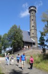 |
SUŠICE – PRODUCTION OF MATCHES
| Length of the route: | 3 km (slow walk about 1 hour) |
| Level of difficulty: | medium, suitable for small children and families |
| Marked: | YELLOW |
| Route description: | Svobody Square – V Brance – 28. ríjna Bridge – T.G.M. Park – Sušice Hospital – K Vyhlídce – Krásná Vyhlídka Observation Point |
| Leaflet: | PDF here |
| Elevation difference: | 262 m |
| Video: | here |
| Foto: | 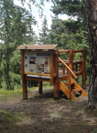 |
SUŠICE AND THE CHALICE
| Length of the route: | 2 km (slow walk about 40 minutes) |
| Level of difficulty: | medium, suitable for smaller children and families |
| Marked: | RED |
| Route description: | Svobody Square – Mostní St – Dlouhoveská St – Pod Kalichem St – red marked route to Žižkuv Peak |
| Leaflet: | PDF here |
| Elevation difference: | 153 m |
| Video: | here |
| Foto: |  |
AN ENJOYABLE MEANDR ALONG THE OTAVA RIVER
| Length of the route: | 3 km (slow walk about 1 hour) |
| Level of difficulty: | easy |
| Marked: | GREEN |
| Route description: | Svobody Square – Kostelní St – Fuferna River Spa – Luh Woodland Park |
| Leaflet: | PDF here |
| Elevation difference: | 7 m |
| Video: | here |
| Foto: | 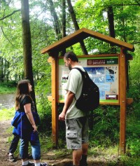 |
A ROUTE OF STUNNING VIEWS
| Length of the route: | 8 km (moderately brisk walk about 8 hours) |
| Level of difficulty: | medium |
| Marked: | BLUE |
| Route description: | Andelícek Hill – Krásná Vyhlídka – Rok – Crossroads: head towards Šibeník – Crossroads: turning to Sedlo – Crossroads: head towards Vrabcov – Divišov – Pátecek – Cervené Dvorce – Horní Dvorce – Crossroads: head towards to the Chapel of the Virgin Mary of Lourdes – Crossroads: turning to Dohalicky – Kocicí skály – Studený kout – Svatobor Hill |
| Leaflet: | PDF here |
| Video: | here |
| Foto: |  |